
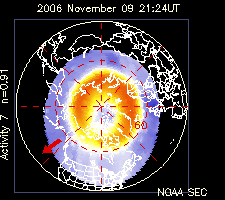
This is a map showing the altitude where the electron density reaches a maximum (known as an hmF2 map, or the height maximum of the F2 layer). The contours are labelled in km above the surface of the Earth. Higher F2-layer maximums can result in propagation to much greater distances than the single-hop limit of about 4,000 km. This information is superimposed on an oblique azimuthal equidistant map projection (described below).
This type of map projection is extremely useful for instantly determining the great-circle bearings to distant regions of the world. It is valid for locations near geographic 40N 100W. The great-circle bearing from 40N 100W to any other location in the world can be determined simply by following one of the azimuthal "spokes" to the destination. For example, the great-circle azimuth to the southern tip of South Africa lies at an azimuth of about 103 degrees (measured from the north). The azimuth to Australia is much less sensitive. Transmissions using azimuths between about 250 and 290 degrees will reach Australia provided the signal does not deviate from the great-circle path. In reality, some deviation is almost certain. The extent of the deviation can only be determined through three-dimensional ray-tracing.
posted by World Radio Club at 1:20 AM
![]()

0 Comments:
Post a Comment
<< Home